

Norway in a Nutshell
After several days of travel Kristen and I finally made it to Norway via a series of airplanes, trains and buses. Whew. There was little to no sleep on the long flight across the Atlantic. Jetlag and sleep deprivation rendered Kristen barely coherent. Upon reaching Stockholm, Sweden, we found a nice outside table cafe as we waited for our overnight train that would take us to Narvik, Norway and north of the Arctic Circle. Located at 66.33 degrees north latitude, the Arctic Circle marks the southernmost extent of the midnight sun on the summer solstice and the ragged edge of polar night on winter solstice. During the first two weeks of our travels in northern Norway we never saw darkness. The sun simply followed an oval arc through the sky, dipping below mountain peaks, only to immediately rise again overhead. As we waited, second-hand cigarette smoke drove us to find a shaded corner of a nearby city park where we could lay down in the grass and wait for our train north.
The train from Stockholm was 20 hours long and rolled thorough sunny green forested countryside of Sweden. The landscape was strangely reminiscent of our home state Oregon. We looked out of our sleeper-car window like kids at gingerbread houses whizzing by. As the train approached the Norwegian border scenery became considerably steeper and dramatic. Fjords and snow-capped peaks peppered the landscape. In Narvik we found a secluded campsite, ate our first real meal in several days and settled in for a long-needed rest. During WWII the strategic port town of Narvik became an obvious target for the Nazi war machine. Epic naval battles ensued here and, consequently, impressive war museums show what life was like in occupied Norway. The next day we gathered supplies and caught the early bus to Slovaer, on the Lofoten Islands, and the start of our sea kayaking expedition.
Lofoten is an archipelago consisting of four main islands, Austvagoy, Vestvagoy, Flakstadoy and Moskensoy. The 200 KM long Lofoten islands are separated from mainland Norway by the Vestfjorden and consist of primarily glacially carved peaks. At our put-in we sorted all our gear, checked over our boats and organized charts. Food, fishing supplies, tent, sleeping bags, rescue equipment, and everything we would need to be self sufficient was all stowed in the bulkheads of our kayaks. In a surprisingly short amount of time concluded packing and quietly slid our kayaks out into a fjord of dreams.
We paddled 6 kilometers north into Vestpollen Fjord with light winds and calm seas. Kristen and I gaped in awe as sheer cliffs rose straight up out of crystal clear water. We glided in with the flood tide and watched hundreds of starfish pass beneath our hulls. Patches of bull kelp offered the only obstacle requiring us to make slight, leisurely alterations to our course. At the head of the fjord we found more massive headwalls at a terminal glacier. We camped on a rocky outcrop with a nice overlook of the amphitheatre surrounding us. It had been several days without washing, so I stripped down and went for a swim. The wash was short-lived, though, as the water was between 30 and 40 degrees F. Kristen laughed from shore as she cut vegetables for dinner. After a replenishing dinner of pasta primavera, we fell asleep in our tent and slept for 12 hours.
When we awoke the next morning we found our kitchen ledge wet with salt water. It was a good thing we moved our gear and boats to higher ground overnight, because the tide had risen 12 feet as we slept. The morning was cool and overcast as we packed up to catch the last two hours of outgoing tide. Each paddle stroke entered calm, glassy water that reflected white cloudy skies. Our kayaks glided silently down a mountain-studded fjord. The grandness was nearly overwhelming. The silence was only broken by a whippoorwill and grey heron. Air passing the heron’s wings could actually be heard from quite a distance. We saw several grey herons in Lofoten. They are quite talented fishermen. Grey herons closely resemble the American Great Blue Heron and will often wait motionless for prey, or slowly stalk its victims.
After paddling until noon, we “podded-up” for lunch. With our boats side-by-side, facing opposite directions, we could easily talk, share hot tea and check our charts together. As we munched on an early lunch we saw a small pod of dolphins in the distance. I think they were Atlantic Spotted Dolphins due to their coloring and spots. When the calves are weaned, they then begin to get their spots, and as the animal matures the spots spread until the body appears black with white spots at full maturation. They came up for air at regular intervals and seemed like the most graceful species on earth.
The sun was now out and a gentle northerly helped push us towards our destination. I tied a spoon hook to a hand line and set it out, letting it trail 30 feet abaft of my kayak. Within two hours I felt a tugging on the line. I had to stow my paddle under my deck bungee to grab the line. “I think I have a fish pulling down. I think it’s big, “is all I could say. Kristen paddled over to assist me. As I pulled in the line I caught my first glimpse as it swam under my boat. Silver and long, it wasn’t putting up much of a fight. As I lifted it to the surface of the water, Kristen scooped the net under it. The cod was about two feet long and I had hooked it in the tongue (which, eerily, resembles a grey human tongue). I did not have anything to string through the gills, so I stabbed it in the head and lashed it to Kristen’s stern deck. The head and tail hung over either side of her boat as she and I paddled to a nearby rocky island. Once there our catch of the day was cleaned and we enjoyed it over a plate of rice and steamed vegetables.
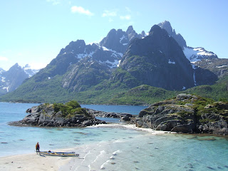
After paddling 24 KM we found a beautiful southeast-facing double lagoon with white-shell beaches extending in all directions. Kristen and I set up camp on this island in the trees where we would be less exposed to the prevailing winds. After dinner we took a stroll around the island to explore the other side. We found an old WWII shipwreck with half of its hull exposed out of the water. Other parts of the wreckage were strewn about the beach and in the turquoise water. We identified hoists, tiller, rigging and large wooden beams. Around midnight dusk settled in (this was as dark as the midnight sun would allow). Mosquitoes increased in number and intensity, so we opted to turn in for the evening. We walked back through a field of wildflowers and noticed Moose tracks surrounding a small pond.
The next morning (feeling a little stiff and sore from our long crossing the previous day) we opted to have a leisurely breakfast of potatoes, sausage, vegetables and tea. Afterwards we paddled south, eventually passing into more coves of white sandy beaches. We glided over sea biscuits, sea urchins, bull kelp, jelly fish and clam shells of all the colors of the rainbow. In the afternoon we paddled into a narrow channel connecting us to another fjord and island 5 KM to the west. “Raftsundet” is actually one of a series of fjords breaking the up the Lofoten archipelago and allowing boats to travel completely though in a north-south orientation. Here, winds picked up to 10-15 knots from the north. Unfortunately, this was the direction we needed to go. So, we worked our way into the headwind, tucking behind small islands of rock and resting in their eddies. Kristen loved it – the rush of the wind, the playful action of the waves rocking the boats and the smooth glide over white-capped seas. Rudders helped keep our course. Spray flew off our paddles and water broke over our bows.
Eventually, we were able to eddy-hop our way north to “Trollsfjord,” a fjord perpendicularly joining the main fjord in a T-shaped intersection. Trollsfjord is a fascinating geologic specimen. It is 1/8th of a kilometer at its widest and 1000 meters deep. Rock walls rise out of the water on either side hundreds of meters up before trailing off to join with the higher mountains. Hanging waterfalls cascade down these cliffs. It was a humbling feeling to be in such a deep and narrow chasm.
The next morning we paddled over to one of the largest waterfalls to fill up our water supply. Kristen mentioned that it sounded as if the cascade were “singing” like a choir of children. While I filled our water containers, Kristen noticed a fat crab sitting underwater near the tide line, its claws moving slowly, picking up algae to the mouth. It did not seem to notice anyone watching, so Kristen floated a little closer. “Want to have it for dinner?” was the obvious question. I braced myself on some rocks and leaned way over holding the fishing net in one hand. I scooped up the unsuspecting crab as it desperately tried to grab for anything it could. The crab was bigger than I expected and would barely fit into the net. With some coaxing I stuffed it in. The crab seemed shocked to be in this predicament. I lashed it, net and all, under the stern deck bungee and we paddled out of our fjord and headed south along the coastline.
Winds were light from the north and seas calm. Sky was clear and temps were warm. Along our corridor monster-huge white capped mountains, the true giants of Norway, rose one after the other out of the fjord. By noon we reached our next camp. We intended to rest and catch up on sleep because we had been pushing hard the last few days and covering a lot of distance. Camp was set up in a meadow of yellow and purple wild flowers with a small brook that wound its way out to the sea. Soon it was time to cook more rice and lentils to eat for lunch with the crab. I carefully removed it from the net, the crab trying to pinch me all the while. I wore gloves in case the crab got off a lucky shot. Placing the crab into the skillet of boiling salt water was a bit tricky. With some fumbling I was able to get it on its back and quickly cover it with the lid. Kristen and I cringed as we heard a little scraping of chitin against the fry pan. I cooked the crab for six minutes on a boil, turned it over and took it out after a few minutes more. We used channel-lock pliers to crack open the legs and peel apart the shell. It was delicious and we smacked our lips with each bite.
That night Kristen awoke around 3 AM and stared outside the tent screen door as a fox walked past and around our food pile to investigate. Kristen woke up an unhappy Bradley who wanted to be left alone, but once the words “fox” and “our food” entered a sleep-induced mind I sat up to look out. The fox was sniffing around our food pile where we had eaten the crab. I yelled at it, but it only froze for a moment. It didn’t look scared, just hungry and annoyed that someone else was here. It was thin and its mouth was open like it might have been rabid. After some time it finally trotted off to inspect our kayaks on the next hill and did not return.
We awoke the next morning to the drone of mosquitoes outside. Eventually, we had to go out, but it was a frenzy of swatting and packing up as quickly as possible. Even mosquito head nets offered little protection. We shoved our gear into our boats and paddled to the middle of the fjord. Several mosquitoes followed us out onto the water until we killed them. Here we had breakfast and hot tea from the thermos, floating side-by-side in our kayaks. We watched a large white-tailed eagle fly over us. I caught a sea perch on my hand line. Seas were calm.
After some discussion we decided to paddle to Litlmolla Island, hoping to not get winded in there. We made the 6 KM crossing in 10 knots of wind and quartering seas. The windiest part of the crossing was a short section where wind funneled through an adjacent fjord and blew onto our beam. Paddling hard and cautiously, we eventually reached a nice set of south-facing beaches. Kristen and I chose one with good southerly protection and white sand and turquoise colored water. As we set up camp we noticed several old ruins. Possibly an old Viking fishing camp? All that remained of them were the stone walls of the structures. A dinner of chicken noodle soup fueled our bodies and afterwards I went for a swim on our own private beach. Wind began to pick up from the east and we grew a bit anxious for tomorrow’s passage, but it steadied at 6 knots or so. We fell asleep in our meadow surrounded by yellow violets and a host of other unknown flowers. Behind us rose tall, steep cliffs with green grass and bushes growing on the lower ledges. Birds called in the distance and gulls squawked. It was like an Eden.
Awoke to fair skies and calm seas. A gift! We ate a hearty breakfast of potatoes and vegetables and fell into a well-rehearsed routine of packing up camp. We were on the water in no time. Our route this day would bring us back to the main islands of Lofoten. After starting the first leg of the day crossing to a group of small islands, we noticed a bigger southerly swell – residual wave energy from a storm out on the Atlantic somewhere. It wasn’t too big, but we wanted to get across in case conditions changed. Weather and sea state can change quickly in a marine environment. We paddled past several “boomers” (rocks just under the water surface that splash up whitewater as the swell passes them) before we reached the main crossing. We weaved between a boomer and another small island of rocks that created a 10-foot high sucking whirlpool as the swell washed on and off. Kristen and I were focused paddlers now and passed more boomers with exploding foam, but kept a safe distance. Seven more kilometers of open-ocean paddling found us at our take-out bridge in Slovaer. After a week of sea kayaking and 80 kilometers traveled in a variety of conditions we had made it back to civilization.
The remaining 2 weeks of our Norway expedition took us to the central mountains in Jotunheimen National Park and later to Arendal and the islands of southern Norway. I will write about this later.
more pics on Facebook:
http://www.facebook.com/album.php?aid=467996&id=673370110&l=734ca49589


